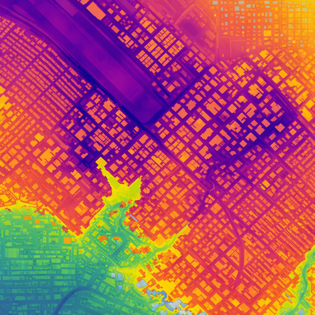
1 x 1 m geospatial resolution land-use cover and terrain data
What is different about our approach?
Resolution

Input data update
Continuous reprocessing of new data

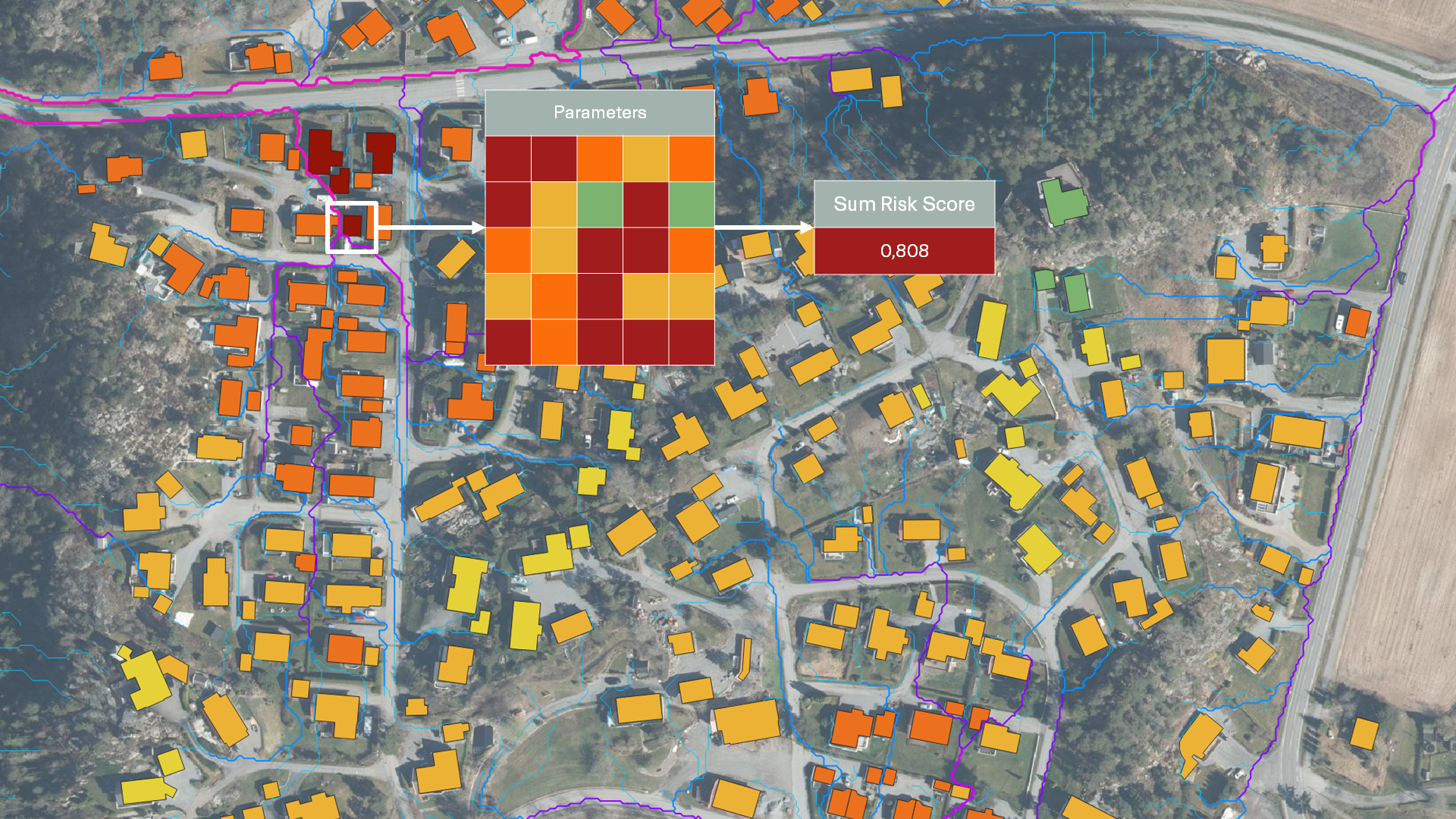
Claims training
Trained and calibrated on verified insurance claims
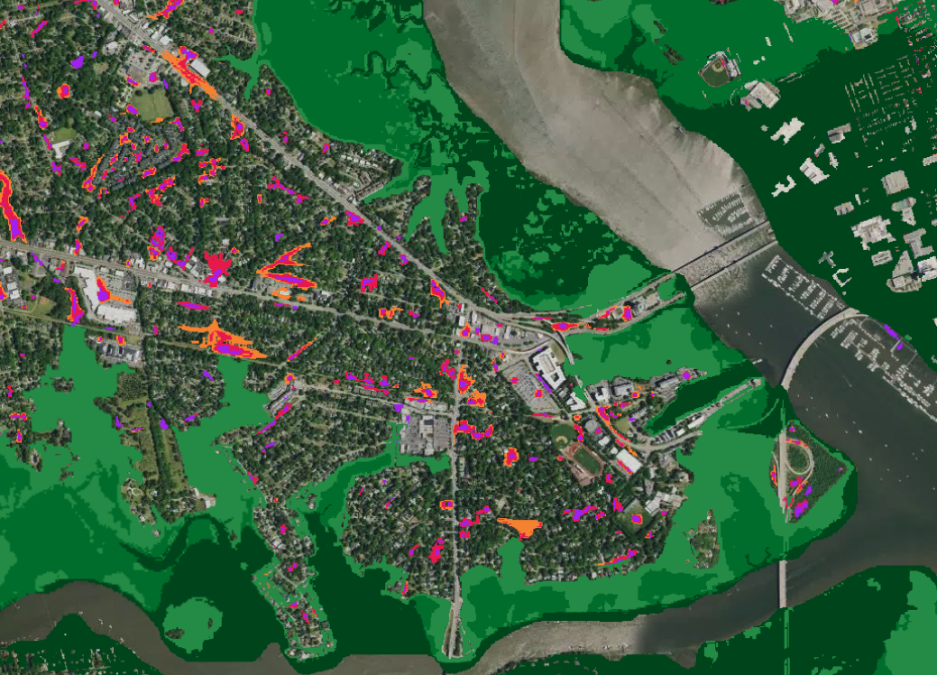
Pluvial Flood Index
The 7Analytics Pluvial Flood Index provides a precise and actionable understanding of surface water flood exposure. It measures the inherent susceptibility of an area to surface water flooding, independent of any historical or simulated rainfall event. It reflects topography, drainage patterns, soil permeability, and land use, providing a stable, static indicator of pluvial vulnerability. This layer is ideal for portfolio screening, risk selection, and pricing support where probabilistic data may not be available.
Unlike traditional flood models that mainly focus on rivers or coastal events, this index captures the impact of intense rainfall and flash flooding—risks that are increasing with climate change and rapid urbanization.
The key challenge with current CAT models is that pluvial flood risk is systematically underestimated, especially in urban areas. At the same time, pluvial flood risk for some buildings can be drastically overestimated in areas which have historically experienced frequent flood events.

Why do we need a new approach to flood risk modelling?
Simply put: the past is not the same as the future—and climate change is accelerating the gap.
In practical terms, 7Analytics addresses this challenge through a set of techniques:
- Climate-agnostic modelling approach – our model is intentionally decoupled from expected weather patterns, ensuring flexibility and future relevance, despite changing precipitation patterns.
- Distinct treatment of vulnerability vs. forecasting – understanding physical vulnerability and predicting weather are two different tasks, which we keep clearly apart.
- Layered weather and climate integration – weather and climate models can be applied on top of the physical risk analysis to reflect different scenarios.
- Urbanization intelligence – unique capabilities in producing and utilizing high-quality data on how urbanization changes terrain and land-use cover.
By combining high-resolution hydrological modelling with this innovative framework, we deliver a street- and property-level view of pluvial flood risk. The dimensionless index score (0 to 1) translates complex hazard simulations into an intuitive metric that supports insurers, asset managers, and municipalities in forming an enhanced view of pluvial risk and taking more informed decisions on how to treat pluvial risk.
Features

What some of our
partners are saying
-

Scott Gunther IAG Firemark Ventures General Partner
Access to real-time, data-driven insights enables insurers to better support customers in understanding and mitigating their risks
-

Pål Sæterhagen, Head of Property Insurance at Fremtind
The collaboration with 7Analytics makes us market leading on physical climate risk
-

Tore Tenold, CEO of KLP Insurance
7Analytics’ innovative flood risk model nicely supplements our existing risk modelling and deepens our understanding of the risk landscape ahead
-

Håkon Hommerstad-Tveit, Head of Product, Data, and Analytics at JBF Insurance
Our collaboration with 7Analytics will not just improve our flood risk assessments but also actively prevent damage and protect our customers’ interests
Use cases
- Pricing new customers more accurately to maximize their profitability
- Renewing existing high-risk customers at higher prices or cross-subsidizing them through lower-risk customers
- Supporting existing customers whose flood risk is high through risk prevention
- Actionable early warning –Push site-specific alerts to clients.
- Data-driven incentives – Offer discounts for resilience initiatives that bring down risk
- Capital efficiency –Reinsurance capital buffers savings
- Event validation independent of historical flood data
- 1×1 meter frequently updated data reflecting real-world changes
- Verified insight for post-event assessment and model calibration
Improve underwriting profitability and price pluvial flood risk more accurately
By using our data, losses due to flooding will be significantly reduced over the next few years by:
Bring down flood claims with early warning solutions
Use our data for damage prevention to bring advanced flood modelling to policy-holders in real-time. As insurer, you will get:
Independent flood event validation powered by 1×1 m models with up-to-date input data
Tricker payout and compare claims with modelled flood depths on a building-by-building basis: